
A blog concerning how urban design and architecture can regenerate urban communities!
 The previous Matrix post proposed an optimistic approach to regenerate Govan by providing a new central community. The image above shows that this area at present is mainly industrial and creates a boundary between the east and west communities.
  Clearing this area and being allowed to start afresh provides an opportunity to impose a new urban fabric and life into the heart of Govan. Industry will need relocated, probably remaining within Govan but aligning the motorway to act as a buffer between residential and the M8.
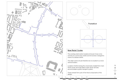
 Now that the area has been cleared the first redevelopment concept is to establish the primary system of major road/street network. This is proposed in the form of 2 streets forming a cross. The north-south orientated road connects to an existing road to the south and will provide access to the south of Glasgow such as Pollokshaws. The northern end of the road crosses the existing Govan Cross and continues towards the river. If this were to lead to a road/foot bridge it is possible to link to Partick Cross and onwards north to Botanic Gardens via Byres road. This would directly link Botanic Gardens with Bellahouston Park and Pollok Country Park. The east-west orientated road provides a direct connection between the two existing communities for the first time in its history. The crossing of this roads provides a new town centre and space to allow new activities such as shopping, markets etc will be given space by the provision of a public square.
 The design of the crossroad pattern has produced quadrants which will most likely be infilled with residential and associated green space. The green space as a route can connect the new town centre into the heart of the residential areas and beyond to specific nodes such as Ibrox stadium.
 The infill blocks are the secondary system. Here I have imposed a circle to complete the proposed urban block pattern of which each block is approximately a hectare in area.
C9th.JPG)
